lunes, 5 de marzo de 2012

Primary economic activity world map


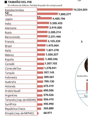
The primary sector consists of economic activities related to the transformation of natural resources in unprocessed primary products. Usually, primary products are used as raw material in industrial production.
The main primary industries are agriculture, livestock, forestry, beekeeping, aquaculture, hunting and fishing.
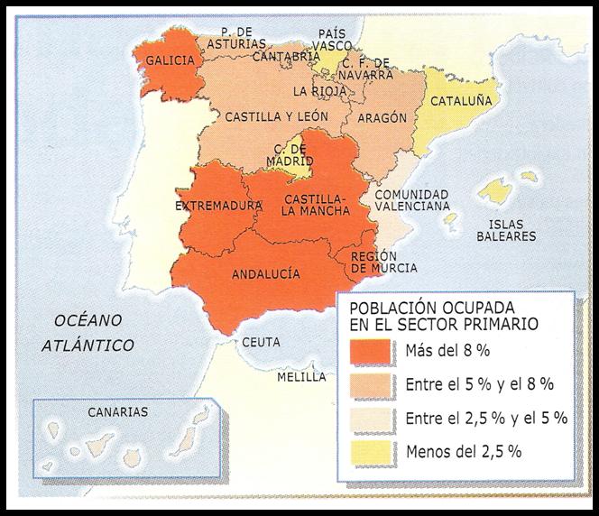
The places where we work more in the primary sector are Galicia, Andalusia, Extremadura, Castile and Murcia.

Gross domestic product of countries in the world


Countries of the world sorted by their gross domestic product (GDP) to values ​​ofpurchasing power parity (PPP), the sum of all final goods and services produced by a country in a year relative to its purchasing power parity (PPP .) This is an economic indicator introduced in the early nineties by the International Monetary Fund in a realistic way to compare living standards between different countries based on GDP per capitain terms of cost of living in each country.

Bar chart of income per capita of the countries E.U

portada PIB todos paises per capita - barras
The country has more income than is the United States.
 Spain is among the lower income countries has yet to receive more revenue than Portugal and Greece.

Physical and political map of America


The physical map shows all American rivers, plains, islands, gulfs, capes ..
Mapa Politico America
And the political map shows all countries

viernes, 2 de marzo de 2012

Physical and political map of Asia

This map shows all over from Asia: rivers, plains, seas, islands ...
Mount Everest is the highest mountain in the world with a height of 8,848 metros.It is located in the Himalayas in Asia, and marks the border between Nepal and China.

In this map are all the countries of Asia and their capitals.